


This map was a first for me. It was my first collaborative map, it was my first map I worked on using LinkedIn’s chat as much as Photoshop, and it was my first exposure to Guerrilla Cartography. Karen reached out to me to work on the Atlas in a Day project, but immediately we had to work around an ironically geographical, problem. She would be working out of Oakland while I was in Colorado.
My normal mapmaking process involves a stray spark of an idea, and then a mad rush of research, design, and editing, all in my home office isolated from the outside world except for coffee. Lots of coffee. It’s an intensely personal process, conforming to my own schedule and entirely up to my own ideas. This can become a problem when there is a client making their own requests, and in the case of truly collaborative maps I had to pass off part of the design duties.
Karen’s eye for design is perfect, not only because it’s clever in ways I could never imagine, but also because it’s different. Every person approaches a challenge in a different way. Having the bravery to exchange ideas freely with someone else through every part of the design process will give results that neither person could have conceived of individually.
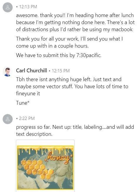
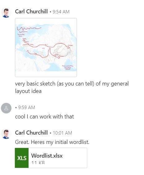
When the Atlas in a Day challenge arrived, we quickly passed a few ideas back and forth and settled on the movement of language. Specifically, the word ‘honey.’ Honey is an ancient word, imbued with deep cultural meaning across thousands of cultures and even more thousands of years. We divided work duties following our relative strengths. I would design the base relief and then I would pass it off for labelling, detailing, and overall design.
Working remotely can be difficult because there is nobody to casually turn to from your chair, ask a question, and turn back to the screen. It takes an extra degree of discipline to be available to talk, to be technically able to communicate, and then to get the important questions settled. Its terrifyingly easy to not open the chat window, plow forward ahead, and remember late at night, oh yeah, maybe I should check in. Karen reached out through LinkedIn, so we used that to communicate. We were both on the computer all day except for travel. I was totally isolated from the other participants in the competition, relying on Karen to pass announcements or ideas back to me. After I produced my relief, I passed it off to Karen to finish.
Any of us can open Google Maps (or Bing Maps, not my preference) and get an accurate, instantly updated, global map of the planet that will automatically plot your way to any destination. It is tempting to think cartography is dead in a world when its apparent purpose is so perfectly realized, but cartography is as much an art as a navigational tool. I treat making a map no differently than writing music. There are only so many sounds, so many chords; but how they are arranged, how they are layered, how they are interpreted produces more combinations than we could ever run through in the total lifespan of the solar system. Like a song, a map tells a story, but instead of soaring over a melody it does that over a landscape. Our map showed how just a single word could travel across half the planet, scattering across language, meaning, and culture. The colors of our map, the vibrant colors and the hexagons, even the fonts, are all choices that Google Maps are not designed to make.
Karen
I first learned of Carl’s work in July, when he won the post-secondary student map competition at the 2019 Esri User Conference. After looking at his portfolio I was excited for any opportunity to work together, and the Atlas in a Day Challenge seemed appropriate – nothing like the pressure of a 24-hour deadline to forge a new working relationship! Happily, Carl agreed, and we began communicating through LinkedIn messaging as soon as the topic was announced, and then throughout the next day, as he worked in Colorado and I headed to the Guerrilla Cartography event in Oakland.
I am new to the Bay Area, and looked forward to meeting some like-minded map people. Everyone at the Oakstop space was super nice, and the encouragement, camaraderie, and idea- sharing flowed freely (along with so much good food!). After we chose our topic and cartographic responsibilities for the Honey Migration map, the rest of my morning was pretty unproductive. Carl’s base map was beautiful, but for my part (design-wise) I wanted something more than just lines. The word we chose lent itself perfectly to a hexagon (honeycomb) shape that thus far in my cartography projects I had avoided – and I even said something like “ok but let’s not overdo the hex symbology…”

So, I covered the entire page with hexagons.
It wasn’t until I got home at about 1pm that my work on this map really started. Honestly, Carl did the research, so we had a lot of back and forth regarding my understanding of the information and how/where to place labels.


As I had told Carl, I was really into this golden yellow color lately, so color and the hex shape were the focus of my design. I used a lot of “darken transparency” in Photoshop for the text and the hexes because it deepened the color to a warm, rich brown while allowing the map to appear beneath.
Collaborating with Carl from remote locations was easy because he was attentive and knows his shit. Thank you, Carl, for the experience of working together on this project. Ours is definitely the most goldeny-yellow page in the book!
